Arlington Heights, Fort Worth: A Neighborhood Profile
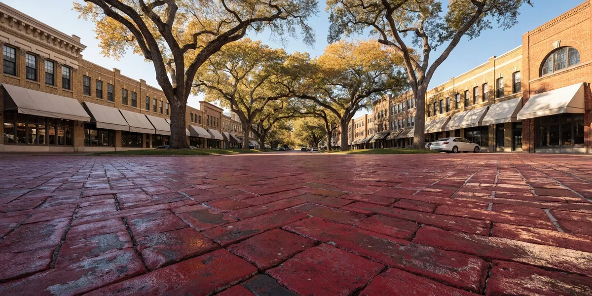
Arlington Heights is a west-side Fort Worth neighborhood strung along Camp Bowie Boulevard, sitting between the Cultural District museums on one end and the Ridglea stretch of the same road on the other. It reads today as one settled place, but it was assembled in three separate waves: a resort suburb that failed in the 1890s, an army camp that covered most of it during World War I, and the housing that filled in on top of both between the wars.
This post is about the place itself. If you are here to price a house, tour one, or check a school assignment for a specific address, book a free consultation and I will run those checks on the address you are looking at.
Snapshot
Arlington Heights at a glance
The orienting facts, before the history.
- Where it is
- West side of Fort Worth, strung along Camp Bowie Boulevard
- Between
- The Cultural District on the east, the Ridglea stretch on the west
- Built in three waves
- 1890s resort plat, 1917 to 1919 army camp, 1920s and 1930s infill
- Housing stock
- Craftsman bungalows, Tudor revivals, and mid-century ranch houses, with no dominant style
- HOA
- Most of the neighborhood has none
- High school
- Arlington Heights High School, Fort Worth ISD, UIL 5A, projected enrollment around 1,900
- Typical price band
- Roughly $380K to $550K, above Fairmount and Ryan Place, below Tanglewood
- Main street
- Camp Bowie Boulevard, paved in Thurber brick since 1927
- Parks
- Trinity Park, about 252 acres, plus the 100-plus mile Trinity Trails network
- Historic designation
- The Linden Avenue Historic District covers part of the neighborhood, not all of it
Price band, school assignment, and flood-plain status all move by address rather than by neighborhood. Every one of them gets verified for a specific lot before an offer goes out.
Why Does Arlington Heights Feel Like Three Neighborhoods Stitched Together?
The neighborhood was built as three. Most of what seems odd about it traces back to that: the mismatched architecture, the commercial spine running straight through the middle of a residential area, and the way block character can change in a single turn. Three different projects happened on the same ground inside about forty years, and none of them finished what it started.
What did the Chamberlin brothers actually build in the 1890s?
Very little that survives today. The Camp Bowie District records that the Chamberlin brothers, Alfred, Humphrey, and Frederic, developed Arlington Heights Boulevard in the 1890s to carry people out to their new suburb, running a trolley from the fresh bridge over the Clear Fork of the Trinity to Chamberlin Arlington Heights and on to the Lake Como resort.
Humphrey Chamberlin, a promoter out of Denver, had bought roughly 2,000 acres to do it. Then the resort hotel he built, Ye Arlington Inn, burned in 1894, and Chamberlin himself died in a bicycle accident in London, according to Juliet George’s neighborhood history “Fort Worth’s Arlington Heights.” What was left was a platted, graded, streetcar-served subdivision with hardly any houses on it.
How did an army camp finish the job?
The war completed what the developer had started. Construction on Camp Bowie started July 18, 1917, and the camp opened officially on August 24, 1917, covering about 2,186 acres and named for the Alamo defender James Bowie. Historic Fort Worth describes the camp as extending north to River Crest Country Club and south to Vickery Boulevard, which means the camp sat on top of the neighborhood rather than beside it. After the 36th Division shipped for France the camp served as a replacement and training facility, then a demobilization center, closing on August 15, 1919 after training more than 100,000 men.
That history explains the housing stock. Land came back onto the market all at once at the end of the war, already graded and already served by a boulevard, and it filled in through the 1920s and 1930s with bungalows and English-cottage houses aimed at middle and upper-middle-class families. Veterans Park, at Camp Bowie and Crestline, is what marks the camp on the ground today.
Timeline
How Arlington Heights got built
Four decades of overlapping projects, in order. Most of what looks inconsistent on the ground traces to one of these dates.
1890s
The Chamberlin brothers plat a resort suburb
Alfred, Humphrey, and Frederic Chamberlin buy roughly 2,000 acres, grade the streets, and run a trolley from the new Clear Fork bridge out to Chamberlin Arlington Heights and on to the Lake Como resort.
1894
The resort burns and the developer dies
Ye Arlington Inn burns, and Humphrey Chamberlin is killed in a bicycle accident in London. What is left is a platted, graded, streetcar-served subdivision with almost no houses on it.
1917
Camp Bowie opens on top of the subdivision
Construction starts July 18 and the camp opens officially August 24, covering about 2,186 acres from River Crest Country Club south to Vickery Boulevard.
1919
The camp closes and the boulevard is renamed
Camp Bowie shuts on August 15 after training more than 100,000 men. The Federation of Women’s Clubs renames Arlington Heights Boulevard to Camp Bowie Boulevard the same year.
1919 onward
The housing fills in
Graded, boulevard-served land returns to the market all at once and builds out through the 1920s and 1930s with bungalows and English-cottage houses.
1927
Thurber brick goes down on Camp Bowie
The boulevard is repaved with hard red brick fired at the Thurber plant southwest of Fort Worth, replacing double streetcar tracks with narrow paved strips.
1936 to 1937
The WPA funds the high school building
Preston M. Geren designs the Georgian Revival campus with a cupola over the crossing gables, set on a hilltop above the Trinity River valley.
1953
The streetcar islands are narrowed
Car lanes are widened at the expense of the islands. The streetcar itself had already gone before World War II.
1978
The boulevard gets a Texas Historical Marker
Restoration of the brick surface has continued since, which is why the street reads as maintained rather than as a survivor.
2012
Linden Avenue Historic District is approved
Fort Worth City Council designates a small number of blocks inside Arlington Heights in October. The neighborhood at large carries no such designation.
What Is the Camp Bowie Corridor Like as a Place?
The corridor serves as the neighborhood’s main street and its commercial frontage, and it is also the main source of traffic noise. It is a commercial strip backing directly onto residential blocks, and Historic Fort Worth notes the most intensive development along it happened between the wars, which is why the yellow and red brick buildings lining it mostly date to the same period.
Why is part of the boulevard paved in red brick?
The name and the surface changed four decades apart. The Federation of Women’s Clubs renamed Arlington Heights Boulevard to Camp Bowie Boulevard in 1919 to commemorate the camp. The street was not repaved until 1927, when hard Thurber bricks went down, and the streetcar islands were narrowed in 1953 to widen the lanes for cars. Historic Fort Worth records that the boulevard was awarded a Texas Historical Marker in 1978 and that restoration of the brick surface has continued since.
Living with the brick is its own consideration. It is louder than asphalt, you feel it through the steering wheel, and it slows traffic more effectively than signage does. It is also the most recognizable feature of the neighborhood, and residents defend it.
What is actually open along the boulevard?
Kincaid’s, at 4901 Camp Bowie, has been serving burgers on the boulevard since 1946 and is the place almost everyone names first. Around it the corridor runs to independent restaurants, small retail, salons, galleries, churches that have been there ninety years and more, and the ordinary services you use during a week.
A restaurant list would go out of date quickly. Roy Pope Grocery, a Fort Worth fixture just off the boulevard for more than eight decades, closed on May 31, 2026, according to the Fort Worth Report. The corridor turns over like any commercial street, so check that a place is open before you build an evening around it.
How Close Are the Cultural District Museums?
Close enough that people here treat them as neighborhood amenities rather than day trips. The eastern edge of Arlington Heights runs into the Cultural District, where the Modern Art Museum of Fort Worth has occupied its Tadao Ando building since 2002, directly opposite Louis Kahn’s Kimbell Art Museum, completed in 1972, and near Philip Johnson’s Amon Carter. The Will Rogers Memorial Center and the National Cowgirl Museum and Hall of Fame sit in the same cluster.
The proximity matters more than the list. An hour at the Kimbell on a Sunday is a short trip from most of the neighborhood rather than a planned outing, and that access does more to draw buyers who could afford elsewhere than any single restaurant on the boulevard.
What Is Everyday Life in Arlington Heights Like?
Everyday life is quieter than the boulevard suggests and more varied street to street than a subdivision. Blocks are short, the sidewalks are continuous, and the trees are old enough to close over the road in places. The tempo depends almost entirely on how many streets you sit back from Camp Bowie: the interior is residential in a way the frontage is not.
The architecture surprises most first-time visitors. Because the land opened in waves, you get craftsman bungalows, Tudor revivals, and mid-century ranch houses within a few blocks of each other, sometimes on the same block. There is no dominant style, and most of the neighborhood has no HOA setting one. That variety is why two houses of similar size here can be very different homes, and why walking the streets tells you more than scrolling listings.
Where do people walk, run, and take the dog?
Trinity Park, at 2401 University Drive on the eastern edge, is the answer most days. The City of Fort Worth puts it at about 252 acres and dates its dedication to 1892, making it the first parkland the city ever bought. It holds a duck pond, a WPA-era shelter, the Dream Park playground built for children of all mobility levels, and a station for the Forest Park Miniature Railroad. Mayfest brings roughly 200,000 people through it every spring.
From the park you are on the Trinity Trails, a paved network of more than 100 miles along the river managed by the Tarrant Regional Water District. That trail network is the main recreation asset here, and most residents reach it on foot.
What Should Parents Know About Arlington Heights High School?
It is the neighborhood’s most visible institution, and the building is a large part of why. Fort Worth ISD records that the current campus was funded by the WPA in 1936-37, designed by Preston M. Geren in Georgian Revival with a cupola over the crossing gables, and set on a hilltop with a view out the back over the Trinity River valley. Wings went on in 1950, 1958, 1980, and 2004, and the grand rear stair survived all of it.
The school is older than the building by forty years. An Arlington Heights Public School opened at 5300 Pershing Avenue in 1896 with every grade under one roof, and the name traveled through several west-side buildings, spending ten years as Stripling High School, before it landed where it is now. The district is also careful to note that Paschal, not Arlington Heights, is the city’s oldest high school, tracing back to 1885.
Day to day it is Yellow Jackets, blue and gold, grades 9 through 12, UIL 5A, with projected enrollment around 1,900. Attendance boundaries do move, and verifying the assignment for one specific street address is a buying step rather than a neighborhood fact, so I confirm the assignment for the specific address with the district before an offer goes in.
What Should You Check on a House That Is Ninety Years Old?
Almost everything you tour here went up before 1940. That age is the reason the houses have the millwork, the porches, and the proportions people come to Arlington Heights for, and it is also the reason two houses of the same size on the same street can sit twenty thousand dollars apart on deferred work alone. There is no dominant builder and, across most of the neighborhood, no HOA enforcing upkeep, so condition varies house by house rather than block by block.
Foundations lead the list. Houses of this era in Fort Worth are usually pier and beam rather than slab, and North Texas clay moves with the seasons regardless of what sits on it. Movement is normal, ongoing movement is not, and the difference is a structural opinion rather than a guess from the curb.
Sewer lines run a close second. Cast iron and clay laterals of this vintage are at or past the end of their service life, and a camera scope is a separate order from the general inspection. It costs a fraction of what a yard dig costs, and it is the single most common surprise on a pre-war house in this part of town.
After those two, the questions are about systems and paperwork: what amp service the panel carries, whether the original wiring was ever replaced, how old the ductwork in that unconditioned attic is, and whether the exact lot sits inside the flood plain or inside the Linden Avenue Historic District. None of these is a reason to walk away on its own. All of them are reasons to write a different number.
Checklist
Older-home due diligence in Arlington Heights
What I look at on a pre-war house here, roughly in the order these items tend to cost money.
- Get a structural opinion on the foundationCheck door reveals, stair-step cracks in the brick, and whether the floors run level, then order the opinion inside the option period rather than after it.
- Scope the sewer lineA camera scope is a separate order from the general inspection. Cast iron and clay laterals of this age fail, and the repair is a yard excavation.
- Ask what amp service the house carriesConfirm whether the original wiring was replaced and when. Insurers ask the same question, sometimes before they will quote a policy.
- Date the HVAC and the ductworkAsk for install dates rather than brands. Duct in an unconditioned Tarrant County attic is its own line item on a summer utility bill.
- Check drainage and the trees near the foundationGrade that pushes water at the foundation and mature roots against a pier line are cheaper to find now than to argue about in an amendment later.
- Pull the flood-plain status for the exact lotSome blocks near University and Trinity sit inside the FEMA flood plain. Search the specific address on the FEMA Map Service Center and on the city’s Flood Risk Viewer, both linked below.
- Confirm any historic designation for the addressThe Linden Avenue Historic District covers a handful of blocks, not the neighborhood. If exterior work is in your plans, the designation on that parcel decides what you can do.
- Verify the school assignment by street addressFeeder patterns move. Confirm the current campus with Fort Worth ISD rather than with a listing sheet.
- Stand in the back yard at 5:30 on a weekdayBrick is louder than asphalt and Camp Bowie carries. How many streets back you sit is a real part of the price.
I pay for the general inspection out of my own pocket on every transaction I represent, buyer or seller. The sewer scope and any structural opinion are separate orders, and I tell you which ones a specific house is likely to need before we tour it.
How Does Arlington Heights Compare With Fairmount, Ryan Place, and Tanglewood?
The comparison below is on character rather than price. These four end up on the same shortlist constantly, and buyers usually choose between them on feel.
- Fairmount is denser, more uniform, and genuinely walkable as a district. The 1920s bungalows repeat, Magnolia Avenue puts the restaurants inside the neighborhood instead of on a road through it, and the historic-register status shapes what owners can do to a facade.
- Ryan Place is quieter and more formal. It is a residential pocket with far less commercial activity of its own, which suits people who want the historic housing without a corridor attached.
- Tanglewood feels suburban despite sitting inside the city. Later houses, bigger lots, car-first daily life, and a price tier well above the other three.
| Feature | Arlington Heights | Fairmount | Ryan Place | Tanglewood |
|---|---|---|---|---|
| How you walk | Walk to the boulevard | Walkable as a district | Quiet, little to walk to | Car first |
| Housing era | 1920s through mid-century | 1920s bungalows | Historic and formal | Later houses, bigger lots |
| Architectural variety | Highest of the four | Lower | Lower | Lower |
| Commercial spine of its own | Camp Bowie Boulevard | Magnolia Avenue | Almost none | Drive to retail |
| Museums within a short drive | ||||
| Facade rules | Linden Avenue blocks only | Historic-register status applies | Verify per property | Verify per property |
| Price position | $380K to $550K | Below Arlington Heights | Below Arlington Heights | Well above all three |
Arlington Heights sits in the middle on nearly every one of those measures. It has more architectural variety than any of the three, a commercial spine none of the others carries, and museums within a short drive that only the Cultural District pockets can match. On price it sits above Fairmount and Ryan Place and below Tanglewood, in the $380K to $550K band, though pricing detail belongs in the guide rather than in a profile.
If you are still comparing broadly, my relocation guide works through picking a side of Fort Worth from scratch.
What About the Flood Plain, Prices, and Actually Touring?
These are transaction questions rather than neighborhood questions, so here are short answers and where to go for the full version.
Yes, part of the neighborhood has a flood-plain problem. Some blocks near University and Trinity sit inside the FEMA flood plain. Whether a specific lot falls inside it is something I check on the FEMA map by address before you write an offer. The risk is real and address-specific, and no neighborhood profile can settle it for a particular house. Pricing, condition, comparable sales, the inspection, and school-boundary verification are all address-specific, and I work through them with you on the property you are considering.
For the wider comparison, the neighborhood rankings put Arlington Heights beside eight other Fort Worth districts on price, schools, and commute. And my buyer representation spells out what I pay for on an older house, starting with the inspection I cover out of pocket.
Where Can You Look All of This Up Yourself?
Every claim above traces to a public source or a public tool, and the address-level questions are ones you can start on tonight without calling anyone.
Resources
Research Arlington Heights yourself
The primary sources behind this profile, plus the tools I use on a specific address before writing an offer.
Search an exact address against the current federal flood map before you write.
- Flood Risk ViewerCity of Fort Worth
The city’s own mapping, including flood studies and the non-FEMA risk areas the federal map does not show.
- Property records searchTarrant Appraisal District
Ownership, assessed value, lot size, and year built for any parcel in the county.
- Schools and feeder pyramidsFort Worth ISD
Confirm which elementary, middle, and high school campus serves a specific street.
- Historic preservation programCity of Fort Worth
Designated districts and overlays, and what a designation means for exterior work on a house.
- Texas Historic Sites AtlasTexas Historical Commission
Look up the 1978 Camp Bowie Boulevard marker and every other recorded marker nearby.
- Camp Bowie Boulevard brick streetsHistoric Fort Worth
The primary source on the Thurber brick, the streetcar islands, and the camp footprint.
- Camp Bowie DistrictCamp Bowie District
The business district’s own listing of what is currently open along the boulevard.
- Trinity Trails mapsTarrant Regional Water District
Trail maps for the 100-plus mile network on the neighborhood’s eastern edge.
Next Steps: Spend an Afternoon on the Boulevard
The fastest way to understand Arlington Heights is to spend time in it. Park near Kincaid’s, walk a few blocks of the brick, then drive one interior street twice, once on a Saturday morning and once on a weekday at 5:30. Ninety minutes tells you more about whether this neighborhood fits you than a week of listing photos will.
Take this with you
A ninety-minute Arlington Heights tour
Print it, work down it, and you will know by dinner whether this is your neighborhood.
- Park near Kincaid’s at 4901 Camp BowieWalk a few blocks of brick in both directions and watch how the storefronts change as you go west.
- Walk one interior street away from the boulevardCount how many streets back the traffic noise drops off. That number is a real part of the price.
- Drive the same street twiceOnce on a Saturday morning and once on a weekday at 5:30. It is a different neighborhood at each.
- Look at three houses on a single blockA craftsman, a Tudor, and a ranch inside a hundred yards tells you the comps here are not a sheet of identical boxes.
- Walk east to Trinity Park and time itMost residents reach the Trinity Trails on foot. Find out from the block you actually liked.
- Photograph anything that reads as movementStair-step cracks in brick, doors that will not close square, fresh patching at the foundation line. Send me the photos before you get attached.
- Check the Kimbell or the Modern on the way homeThe museums are the amenity that buyers who could afford Tanglewood come here for. Fifteen minutes tells you whether that matters to you.
Send me the address of anything you liked and I will pull the flood map, the appraisal-district record, and the last four comparable sales on it before you tour a second time.
What an afternoon will not tell you is which side of the flood map a specific lot falls on, what the foundation has been doing for eighty years, or what the last four comparable sales really mean. Book a free 10-minute Initial Consultation, with no obligation, and I will tell you whether Arlington Heights is your neighborhood or whether one of the other eight is the better fit. If you would rather talk now, call me at 806-928-8884.
Frequently Asked Questions
Is Arlington Heights part of Arlington, Texas?
No. Arlington Heights is a neighborhood on the west side of the City of Fort Worth, strung along Camp Bowie Boulevard between the Cultural District and the Ridglea stretch of the same road. Arlington is a separate city east of Fort Worth with its own government and its own school district. The shared word causes real confusion in searches and on relocation spreadsheets, so it is worth pinning down early: an Arlington Heights address is a Fort Worth address served by Fort Worth ISD.
Is Arlington Heights the same thing as the Cultural District?
They are neighbors, not the same place. The Cultural District is the museum cluster east of Arlington Heights that holds the Kimbell Art Museum, the Modern Art Museum of Fort Worth, the Amon Carter, the National Cowgirl Museum and Hall of Fame, and the Will Rogers Memorial Center. The two run into each other with no hard edge, which is why listings sometimes blur them. Fort Worth’s own neighborhood mapping treats Monticello and the Cultural District pockets as their own thing, priced differently from Arlington Heights proper.
Why is Camp Bowie Boulevard paved in red brick?
The street was repaved in 1927 with Thurber brick, a hard red paving brick fired at the Thurber plant southwest of Fort Worth, according to Historic Fort Worth. Before that it carried double streetcar tracks with narrow paved strips on either side. The streetcar islands were narrowed in 1953 to widen the car lanes, the streetcar itself was gone before World War II, and restoration of the brick surface has continued since the boulevard received a Texas Historical Marker in 1978.
Can you walk to restaurants and shops from Arlington Heights?
From most of the neighborhood you can walk to Camp Bowie Boulevard, and the boulevard is where the restaurants, salons, small retail, galleries, and churches are. What you cannot do is walk between destinations along its whole length, because the corridor is long and car-scaled at the edges. In practice you walk to the corridor rather than along it. Kincaid’s at 4901 Camp Bowie has been the anchor on that spine since 1946.
Does Arlington Heights have a historic district designation?
Parts of it do; the neighborhood as a whole does not. The Linden Avenue Historic District, inside Arlington Heights, was approved by Fort Worth City Council in October 2012, and the city’s historic preservation program lists it among its designated districts. That covers a small number of blocks, not the neighborhood at large. Camp Bowie Boulevard separately carries a Texas Historical Marker awarded in 1978. If exterior work matters to your plans, confirm the status of the specific property rather than assuming the neighborhood label applies.
What high school serves Arlington Heights?
Arlington Heights High School, a Fort Worth ISD campus whose mascot is the Yellow Jacket and whose colors are blue and gold. It runs grades 9 through 12, competes at UIL 5A, and projects enrollment around 1,900. Fort Worth ISD lists its feeder pyramid as Burton Hill, the Leadership Academy at Como, North Hi Mount, M.L. Phillips, Ridglea Hills, and South Hi Mount elementaries, with Monnig and Stripling middle schools. Attendance boundaries do shift, so verify the assignment for a specific street address before it factors into an offer.